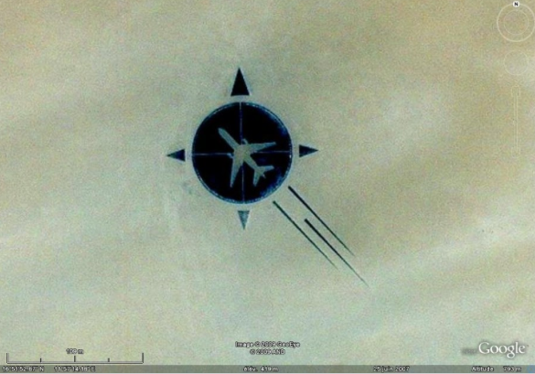
Last night, I came across and incredible blog post dedicated to the memorial of UTA Flight 772 (French airline Union des Transports Aériens) that crashed in the middle of the Sahara desert nearly 25 years ago.
If you’re like me and just learning about this crash for the first time, here’s a quick backstory:
UTA 772 was a scheduled flight operating from Brazzaville in the Republic of Congo, via N’Djamena in Chad, to Paris CDG airport in France.
On September 19, 1989, the McDonnell Douglas DC-10 aircraft registered N54629 took off from N’Djamena International Airport at 1:13 pm. Just forty-six minutes later, at cruising altitude of 35,000 feet, an explosion caused the aircraft to break up over the remote African desert near the towns of Bilma and Ténéré in Niger. All 156 passengers and 14 crew members died in the crash.
I challenge you to type in these co-ordinates into Google Earth: 16°51’53″N  11°57’13″E
This is the image you’ll see:
You’re probably wondering how on Earth did Google Earth came up with that icon right at the crash site?
The astonishing part of the story is this: what you’re seeing on Google Earth is the final product of a remarkable 200-foot diameter memorial built by hand 18 years later, by the victims’ families and with the help of the local villagers, that could be seen from anywhere on earth… literally.
I am definitely moved by this story. I encourage you to take a deeper look into the creation and story behind the memorial of flight UTA 772 by going here.
What are your thoughts?
Let’s connect: Twitter | Facebook | Subscribe | japt.co


Leave a Reply